Acquiring satellite imagery for your specific use case requires several steps.
Here’s a step-by-step guide to help you:
- Define your use case: Clearly define your purpose for acquiring satellite imagery. Determine what specific information or data you need to extract from the imagery and how it will be used. This will help you narrow down your search and select the most relevant imagery. At GeoSyze, we can offer help in understanding the significance of geospatial technology in addressing the problems of your use case.
- Understand the type of Imagery required: When considering satellite imagery for your use case, it is crucial to understand the specific type of imagery that meets your requirements i.e. Optical imagery or SAR imagery, both are have their own distinct advantages based on the use case.Consult with an experts or providers like GeoSyze who can assist you in identifying the appropriate type of imagery based on your use case or need.By gaining a clear understanding of the required imagery, you can narrow down your search and select the most suitable satellite data for your project.
Let’s dive into more details about different types of satellite imagery and their relevant parameters:
- Optical Imagery: Optical satellite imagery captures the Earth’s surface using visible, near-infrared, and shortwave infrared wavelengths of light.These images provide visual representations of the Earth’s features and are commonly used for various applications such as mapping, land cover classification, urban planning, and environmental monitoring.
Relevant Parameters for Optical Imagery:
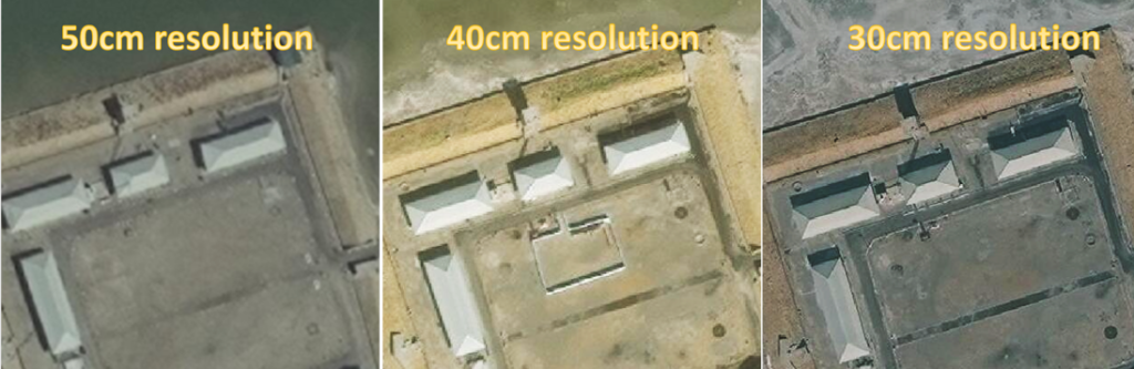
- Spatial Resolution: Spatial resolution refers to the level of detail or ground sampling distance (GSD) captured by each pixel in the image. It determines the smallest discernible feature in the imagery. Higher resolution imagery provides more detailed information but may come at a higher cost.Some of the example of spatial resolutions are as follows i.e.
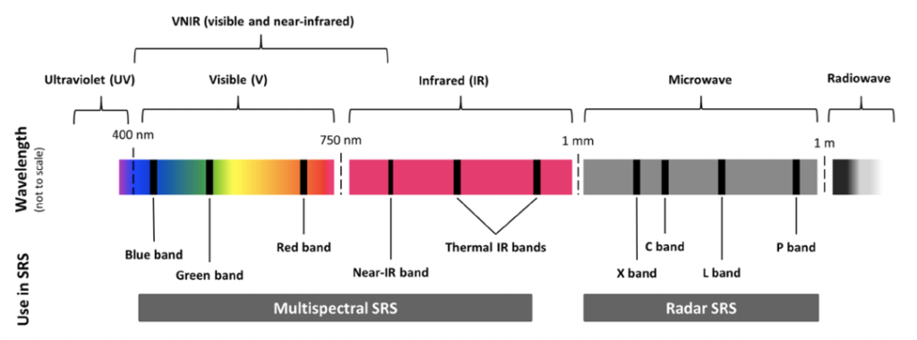
- Spectral Bands: Spectral bands are specific ranges of wavelengths captured by the satellite sensors. Different bands capture different types of information about the Earth’s surface. For example, the red and near-infrared bands are useful for vegetation analysis, while the blue band can help identify water bodies. The number and combination of spectral bands vary among satellite sensors and providers.

- Temporal Resolution: Temporal resolution refers to how frequently images are captured over a specific area. If your use case involves monitoring changes over time or studying dynamic phenomena, such as crop growth or urban development, a higher temporal resolution (frequent revisit times) would be important.
- Spatial Accuracy: Most satellite imagery is delivered georeferenced or georectified, but not orthorectified, which is a process that improves absolute accuracy by correcting for terrain displacement. Therefore, the accuracies listed are exclusive of terrain displacement, which is significant in areas of high relief.Typically, horizontal accuracy is expressed as CE90 (Circular Error 90 percent), but it may also be expressed as RMSE (Root Mean Square Error) or as a scale. For example, to comply with US national map accuracy standards for 1:12,000 scale, an orthorectified image would need to achieve 10-meter CE90 accuracy.
- Off-Nadir Angle (ONA): The Off-Nadir Angle refers to the angle between the satellite’s line of sight and the vertical direction. Lower ONA values indicate a more perpendicular view of the Earth’s surface, resulting in less geometric distortion and better spatial resolution. Higher ONA values occur when the satellite captures imagery from a more oblique angle, which may introduce geometric distortions and reduce the effective resolution.Consider the desired ONA based on your application requirements.

- Cloud Cover: Cloud cover refers to the extent of clouds present in the satellite imagery. Cloud cover can obstruct the view of the Earth’s surface and affect the quality and usability of the imagery. It’s important to consider the acceptable level of cloud cover for your specific use case. Some providers offer cloud- free or cloud-masked imagery, which can be useful for applications where cloud cover is a concern.
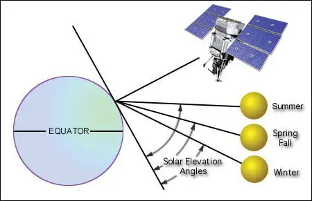
- Sun Angle: The Sun angle refers to the angle between the sun’s rays and the Earth’s surface at the time of image acquisition. Sun angle affects the illumination and shadowing of objects in the imagery. The angle can impact the visibility of features, surface texture, and the interpretation of the image. Different sun angles can be relevant depending on the time of day, season, and specific analysis requirements.
- Synthetic Aperture Radar (SAR) Imagery: SAR is an active remote sensing technology that uses microwave signals to capture images. Unlike optical imagery, SAR is not dependent on sunlight and can acquire data day and night, as well as through clouds and fog. SAR is widely used for applications like disaster monitoring, terrain analysis, agriculture, and maritime surveillance.
Relevant Parameters for SAR Imagery:
- Frequency Band: SAR imagery is categorized based on the frequency band used to capture the signals. Common frequency bands include X band, band, L band, and others. The choice of frequency affects the imaging capabilities, including resolution, penetration through vegetation or soil, and sensitivity to certain features. Higher frequencies generally offer higher resolution but may have limitations in terms of penetration.
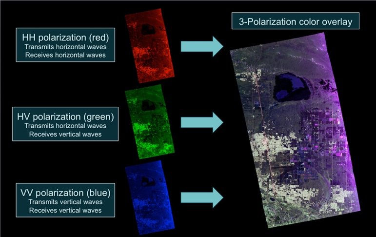
- Polarization: SAR imagery can be captured in different polarization modes, such as Single Polarization (HH or VV), Dual Polarization (HH+HV or VV+VH), or Fully Polarimetric (HH, HV, VV, VH). Polarization information provides insights into the physical properties of the observed targets, allowing for advanced analysis, such as target characterization and land cover classification.
- Spatial Resolution: Similar to optical imagery, SAR imagery also has spatial resolution, which determines the level of detail in the image. SAR resolution is usually described as slant range resolution and azimuth resolution, which are affected by antenna design and processing techniques.
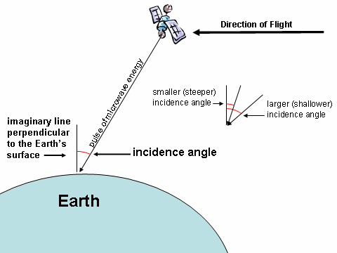
- Incidence Angle: The incidence angle is the angle at which the SAR signal hits the Earth’s surface. It affects the image quality and interpretation, particularly for surface roughness, backscattering properties, and target detection. Different applications may require specific incidence angles based on the desired outcome.
- Identify satellite imagery providers: Identifying satellite imagery providers that offer data suitable for your use case. This is one of most trickiest part of the entire process, as the options for satellite imagery are endless in the market. At GeoSyze, we understand the difficulties involved in navigating through this option. That’s why we go beyond simply providing imagery. We offer expert guidance and unwavering service to ensure your project receives the attention it deserves.
- Check Archive availability and Access options: Contact the satellite imagery providers or explore their websites to check if the required imagery is available in their archive for your area of interest, if not you need to order for fresh collection of satellite imagery. Some satellite imagery providers offer online portals or APIs for easy access to their data. Determine the pricing, licensing terms, and data delivery options.
- Select and order imagery: Once you’ve evaluated the available options i.e. Archive or Tasking, select the satellite imagery that best fits your requirements. Follow the provider’s ordering process, which usually involves specifying the area of interest, acquisition date, and any additional specifications. Provide the necessary details and complete the purchase or licensing agreement.
- Receive and process the imagery: After your order is confirmed, the satellite imagery provider will deliver the data to you. Depending on the provider and the chosen delivery method, you may receive the imagery via download links or physical media. Once received, process the imagery using appropriate software or tools to extract the desired information.
- Analyze and interpret the imagery: Use image processing and analysis techniques to extract the relevant information from the acquired satellite imagery. This could involve tasks like object detection, classification, change detection, or image enhancement. Apply appropriate algorithms or tools based on your use case requirements.
- Integrate or present the results: Integrate the extracted information into your desired application or present the results in a suitable format. This could involve creating maps, generating reports, visualizing the data, or incorporating it into a larger analysis workflow.
Remember that acquiring satellite imagery may involve costs, licensing agreements, and considerations regarding data privacy and usage restrictions. It’s important to comply with the terms and conditions set by the satellite imagery providers and ensure you use the data ethically and legally.
To make informed decisions in your journey into the geospatial, it is essential to comprehend these parameters and their significance in relation to your specific use case. By understanding these factors, you can select the most appropriate satellite imagery and optimize your analysis accordingly. GeoSyze provides consultancy services to address these challenges and assist you in making informed decisions, ensuring that you leverage the full potential of the geospatial domain.